Logistics & Preparation
Thru-Hike Basics
|
length |
1,100 miles |
|
duration |
2-3 months |
|
when |
late December to early April |
|
cost |
$2500 - $3300 for on-trail expenses |
|
direction |
south to north is best |
|
begin |
Oasis Visitor's Center, Big Cypress National Preserve |
|
end |
Fort Pickens, Gulf Islands National Seashore |
|
permits required? |
yes—obtained in advance, & you must join the Florida Trail Association |
|
first thru-hiked |
1989, by Steve Sheridan |
| annual # of thru-hikers | since 2005, between 5 & 20 |
|
total # of end-to-end hikers to date |
about 160 |
When to Thru-Hike: Jan 1st - March 31st

Since the trail is open year-round and is never blocked by snowfall like the AT or PCT, you could potentially thru-hike at any time of the year. However, the Florida hiking season lasts January through March, and FT thru-hikers traditionally begin between January 1st and 5th because of four issues:
High Temperatures
Floridians look forward to the onset of fall the way a northerner looks forward to spring and Florida's hiking season is the opposite of the rest of the country. During the odd cold year,
backpacking is pleasant October through April. More often, the heat lingers until November and returns by the end of March. Beginning in April, daytime temperatures are regularly above 90
degrees. These temperatures combined with high humidity means it is difficult for the body to cool down, and heat stroke is a real danger. more
Thunderstorms & Flooded
Trail
During the summer, intense storms with lightning appear every afternoon and their heavy rains inundate the trail, submerging many parts of it. Only in the cool, dry months of December to March
does the land dry out. We have been hiking on the FT during a thunderstorm, with lightning striking all around us. It was dangerous, and there was little we could do. While it still rains in the
winter, the storms are more mild and infrequent. more
Bugs
Once the heat and rain returns, biting insects like mosquitoes, horse flies, ticks, and chiggers appear. Spring and early summer are the worst times of year to backpack, because chiggers and
horse flies are at their peak. more
Alligator Mating Season
While alligators are usually shy and encounters with people are rare, during mating season males wander outside their usual territory, leading to frequent run-ins with people. Courtship begins in April, followed by mating in May and June. During these months alligators also become generally more aggressive.
Length of a Thru-Hike
It takes about 2-3 months to hike all 1,100 miles. If you start during the first week of January, you will likely finish sometime in March.
If we assume an average of 13 miles per day (which is a leisurely pace), and assume you will take a zero day about once every 7 days, then we can do the following math:
1100 miles divided by 13 miles per day = 84.5 days (Jan 1 to March 26)
+ 11 zero days = 95.5 days (Jan 1 to April 6)
Or, if you prefer to go faster:
1100 miles divided by 16 miles per day = 68.6 days (Jan 1 to March 10)
+ 11 zero days = 79.6 days (Jan 1 to March 21)
Should You SOBO or NOBO?
NOBO. Like on the AT and PCT, most thru-hikers begin at the southern terminus and hike north. On the AT and PCT you hike with spring — as hikers head north, warm temperatures move north with them. But on the FT, a thru-hike takes place entirely within the winter. Why then, does it matter where you start? The short answer is, a northbound (NOBO) hiker avoids extreme cold and freezing rain, as well as extreme heat:
- January temperatures in North Florida can drop below freezing and weekly cold fronts bring icy rain. A southbound (SOBO) hike beginning in January would be a wet, freezing, miserable endeavor.
- By March, south Florida is broiling. A SOBO thru-hiker who started in January would reach Big Cypress at the onset of dangerously high temperatures, as well as swarms of insects.
- In contrast, January temperatures in the absolute far south of the state are mild, even warm. You will be surprised how hot Big Cypress gets in January, but it's nothing compared to summer. Hiking north keeps you aligned with mild temperatures.
Optional Routes
Unlike most other National Scenic Trails, the official Florida Trail has loops and alternate routes that make the traditional "purist" concept of a thru-hike impossible to apply. To successfully hike the "whole trail," you need to abandon the idea that you could actually hike every foot of trail that has been blazed orange.
We've all heard about guys on the AT who never took a blue blaze or loop trail because they insisted they wanted to hike "the whole AT." Get that idea out of your head and don't listen to anyone who says you have to hike a specific route in order to be a "real FT thru-hiker." On the Florida Trail, the meaning of "hike your own hike" is taken to new extremes. With so many options and loop trails, any route you choose is your thru-hike.
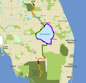
Left or Right Around Lake Okeechobee?
The official FT route encircles all of Lake Okeechobee, and so thru-hikers approaching from the south have to choose whether to go east or west around the lake.
The lake, second largest entirely within the US, is ringed by the massive earthen Herbert Hoover Dike. The trail goes along the
top of the dike, but so does a paved bike path. In the picture to the right, the purple represents paved trail, while green is unpaved trail. At the moment there is less pavement on the western
side, but that is changing. Plans are in the works to pave the entire path.
The east and west routes also have different views. Huge marshlands border the western side of the lake, and rarely will you see open water. However you will see a lot of birds. The eastern side provides great views of the open water, but has fewer birds. Finally, the Herbert Hoover Dike is in a constant state of repair by the Army Corps of engineers. Construction means the path is closed and the trail detours onto roads. As of 2014/2015, there is less construction, and hence fewer roadwalks, on the western side.

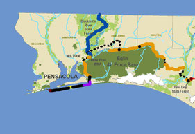
East or West Around Orlando?
The official trail route makes a huge loop around the Orlando area. The biggest decision the thru-hiker has to make is whether to go east or west around Orlando.
In the map to the right, orange represents trail through wild lands, while dotted lines represent road walking. So while the western route goes through gems like the Green Swamp, the Withlacoochee State Forest, and the Cross Florida Greenway, a NOBO thru-hiker faces 64 miles of continuous road walking at the very beginning of the western route. Both options have roughly the same amount of roadwalking, but 64 unbroken miles is a bit daunting, and so most hikers go east.
Finish in Alabama or at Fort Pickens?
Near the end of Eglin Air Force Base section, in the town of Harold, the trail reaches an intersection and hikers can turn north into the Blackwater River State Forest or south to eventually reach Ft. Pickens.
The turn into Blackwater is a connector that ties the Florida Trail to the Eastern Continental Divide Trail. The traditional FT thru-hike route heads south and ends at Fort Pickens.